
Flooding in the Carson River Watershed is a natural process that occurs on a regular basis. It is also one of the most devastating and costly natural events that our communities face. Serious flooding can happen approximately every 10-20 years and often occurs after rain-on-snow events or summer thunderstorms. The Carson River is unique; there is extremely limited upstream water storage capacity or capability, and there are no flood control structures within the river. However, open floodplains, especially in Hope Valley, Carson Valley, and Dayton Valley, provide our watershed with the best flood control mechanisms available!
Check out our “Floodplains As Community Assets” Videos!
During a flood, open floodplain benefits our watershed by storing and slowing flood waters; helping protect our natural resources such as drinking water and wildlife habitat; and avoiding costly damages to structures associated with more developed lands. Protecting the natural functions and values of our floodplain areas are central to maintaining a “living river” and limiting the devastating property loss from flooding in our watershed. In 2003, the University of Cooperative Extension surveyed CRC members to identify the most important issues that are facing our watershed.
 Carson Water Subconservancy District’s (CWSD) Watershed program manager works closely with our partners through the Carson River Coalition (CRC) stakeholder process to coordinate, plan and identify funding sources to create watershed-wide solutions that reduce our flood risk and protect our floodplain. Stakeholder coordination occurs through working groups, CRC Forums and bus tours and workshops.
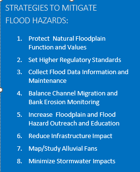
The CRC Floodplain Management Working Group meets regularly address floodplain management in the Carson River Watershed. This group also serves as the steering committee for the Carson River Watershed Floodplain Management Plan (PLAN). This plan has been adopted by all watershed counties and includes Suggested Actions to mitigate flood hazards and improve watershed health. CWSD’s Water Resource Specialist II works with local staff to write and manage grants to complete numerous plans & studies and conduct risk communication outreach throughout the watershed.
In 2005, CWSD signed the Cooperative Technical Partner Agreement with Federal Emergency Management Agency (FEMA). The Original Floodplain Management Plan was adopted by five counties adjacent to the Carson River in 2008 and is updated every five years. Since 2018 all six counties have adopted the PLAN. In 2012, the various counties located along the Carson River, State and Federal agencies entered into a Risk MAP Charter agreement with FEMA. The Charter agreement enables FEMA, CWSD, and counties to work on flood related issues on a watershed basis instead on a county by county basis. This was the first Charter Agreement in FEMA Region 9 and is a blueprint for other regional cooperation programs.
Click on the Link below to access the Carson River Watershed Floodplain Management Plan.
![]()