
About Carson City’s High Water Mark Mural Project:
High Water Mark Unveiling and Disaster Preparedness Festival Video
Flooding is the number one natural disaster in the United States. However, when surveyed less than one-third of respondents believed their community was at risk for flooding. [1] We want our residents to know that NevadaFloods. “Carson City uses flood management tools to help reduce damage from flooding. A few ways include providing open space for flooding, constructing detention basins and systems to handle flood water, establishing a flood protection ordinance, and providing public education and outreach,” said Robb Fellows, Carson City’s Floodplain & Stormwater Manager.
Black & White Conceptual Mural: Final Finished drawing pdf
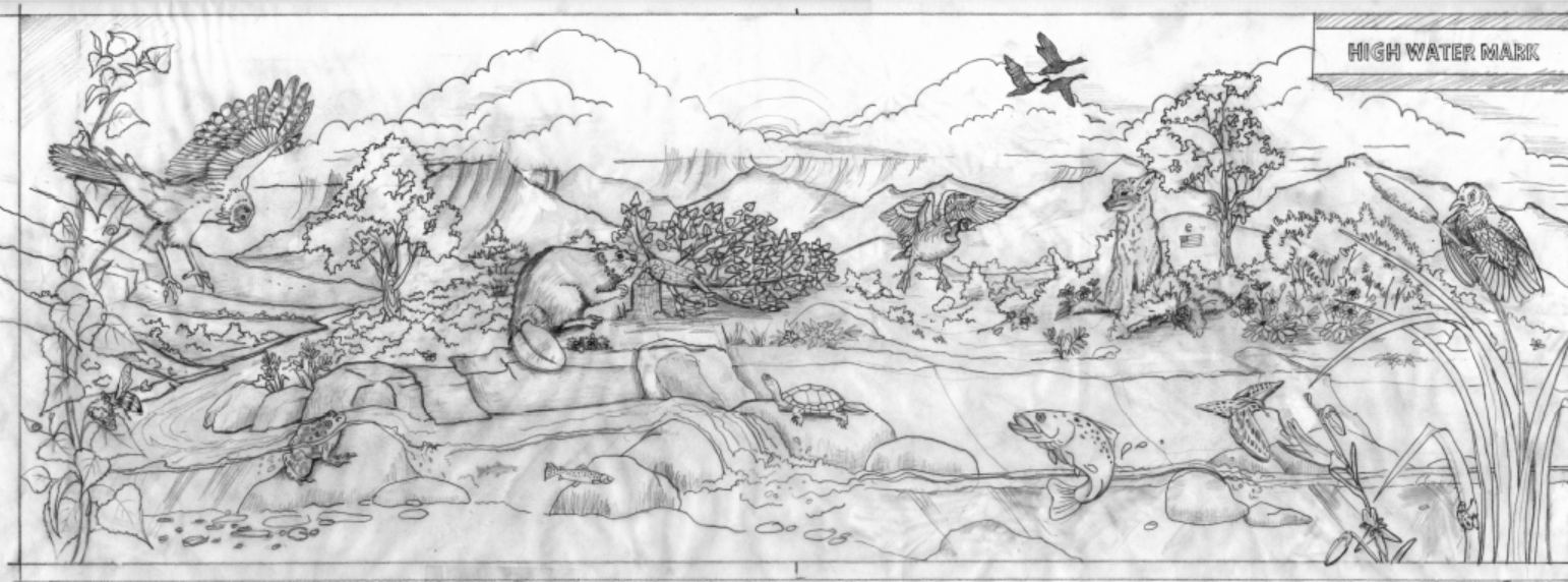
This high water mark project is an outreach tool designed to let people know their flood risk and to underscore how floodplains and open space work together to reduce their flood risk. Open floodplain lands reduce flood damage by allowing water to slow down, spread out and sink in. These lands also recharge groundwater and filter pollutants.
Approximately 11 miles along the banks of the Carson River are dedicated as open space to not only preserve floodplain, but also protect wildlife habitat for migratory birds, aquatic life and mammals, as well as pollinators! Additionally, these lands provide passive recreation opportunities for residents and visitors, including 5 miles of contiguous river trail system and 13 miles of Aquatic Trail that links Carson and Lyon County and allows for rafting and kayaking. Access to trails and recreation opportunities increases the quality of life for Carson City residents, and lends to a happier, healthier community.
Press Release for Carson City HWM Mural_Final
Snapshot of Interpretive Sign: Web HighWaterMark_pdf

FEMA funded this High Water Mark project through a Cooperating Technical Partners (CTP) grant to help improve the public’s awareness of flood risk and encourage communities to take long- term action to address this risk. With CTP FEMA funding, Carson City has been able to systematically plan the best approach to reduce flooding from rain, flash floods and riverine floods. That information has been utilized in the City’s Capital Improvement Plan, in creating a drainage manual, and in updating the floodplain ordinance.
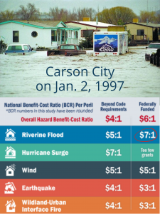
For every $1 Carson City spends to reduce flood risk, $7 is saved when disaster strikes [2].
Carson City residents can prepare for emergencies with Carson City’s Emergency Preparedness and Evacuation Guide. Residents can obtain this guide by contacting the fire department or Public Works.
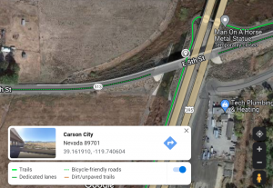
The mural is located below the East 5th overpass west of I-580. It is along linear trail #1. Refer to to map at the bottom of this page.
Meet the Artist: Debra Fong
 Debra has been an artist most of her life, selling her first piece in the 1970’s, during art school. In the late 1980’s and into the 1990’s, she worked as an artist on a US Army test facility. One thing led to another, and an opportunity in the civil engineering field opened up. She soon discovered that she loved computers and also liked to design civil infrastructure as well. However, she always created art on the side part-time. Debra has worked with many different art media such as airbrushing and pinstriping on vehicles, motorcycles, and helmets, metal sculpture and scrimshaw work, carving wood and stone. In the early 2000’s, the thought developed, that it might be nice to create public artwork. In 2021, Debra retired from Carson City Public Works doing civil design work and now pursues her artistic passions in between camping, biking, skiing, roller blading and skateboarding.
If you would like to get in touch with her, drop her an email at deb@jungledesigns.com
Project Location:
Project management for this project was provided by Carson Water Subconservancy District. Robb Fellows, Carson City’s Stormwater Manager was the project’s technical lead.
[1] https://www.fema.gov/flood-maps/products-tools/high-water-mark-initiative
[2] http://2021.nibs.org/files/pdfs/ms_v4_overview.pdf
[3] Carlos Rendo, Nevada Division of Water Resources, Floodplain Management